 CLICK TO
ENLARGE
CLICK TO
ENLARGEEvolution Cruncher Chapter 14
Effects of the Flood part 2
One survey of 120 tribal groups in North, Central, and South America, disclosed flood traditions among each of them (*International Standard Bible Encyclopedia, Vol. 2, p. 822).
(1) There was general wickedness among men.(2) God saw that a flood was necessary.
(3) One family with eight members was protected.
(4) A giant boat was constructed.
(5) The family, along with animals and birds, went into the boat.
(6) The flood overwhelmed all those living on the earth.
(7) The deluge covered all the earth for a time.
(8) The boat landed in a high mountainous area.
(9) Two or three birds were sent out first.
(10) The people left the boat with all the animals.
(11) The survivors worshiped God for sparing them.
(12) A promise of divine favor was given that there would not be another worldwide flood of waters.
Another survey of ancient Flood literature and legends is discussed by B. Nelson in The Deluge Story in Stone (1968). In this tabulation, the stories and writings of 41 different tribal and national groups were given.
First, we will list these 41 groups, many of which were ancient races. ("A and B" indicate two different sub-groups; example: Fiji A and B.)
Assyria-Babylonia (A and B), Alaska, Andaman Island, Asia Minor, Aztecs, Brazil, Cherokee, China, Cree, Egypt, Esquimaux (Canada), Fiji (A and B), Greece, Hawaii, India (A and B), Italy, Lapland, Lenni Lenape, Lithuania, Leward Islands, Mandan, Michoacan, Nicaragua, Papagos (Mexico), Persia (A and B), Peru, Pimas, Russia, Scandinavia (A and B), Sumatra, Syria, Takoe, Thlinkut (A and B), Toltecks, Wales.
Second, we will list twelve points in their legends, according to the number of times each is included by each of the 41 groups.
Destruction by a flood—41 times.Some humans saved—38 times.
A boat saved them—36 times.
Universal destruction by the flood—24 times.
One family was especially favored for protection— 15 times.
The flood was caused by man’s transgressions—14 times.
The flood came as a result of a divine decree—10 times.
Birds were sent out first—9 times.
Animals were saved by the boat also—8 times.
The survivors worship God after leaving the boat—7 times.
The boat landed in a high mountainous area—6 times.
After leaving the boat, God spoke favor to the saved—5 times.
An even larger collection of Flood stories is to be found in *Sir James G. Frazer’s book, Folklore in the Old Testament (1919), Vol. 1, pp. 146-330. There are 11 Hellenic stories from ancient Greece, 6 European stories, 29 Persian and Indian stories, 31 Australian, Southeast Asia, and Pacific stories, 63 North, Central, and South American stories, and 3 African stories related in 185 pages of Frazer’s book; a total of 143 Flood stories. You will find them listed in Donald W. Patten (ed), Symposium on Creation IV (1972), pp. 36-38.
An excellent five-page analysis of confusion-of-tongues legends will be found in James E. Strickling, "Legendary Evidence for the Confusion of Tongues, "in Creation Research Society Quarterly, September 1974, pp. 97-101. Quotations from a number of sources are given.
"There are many descriptions of the remarkable event [the Genesis Flood]. Some of these have come from Greek historians, some from the Babylonian records; others from the cuneiform tablets [of Mesopotamia], and still others from the mythology and traditions of different nations, so that we may say that no event has occurred either in ancient or modern times about which there is better evidence or more numerous records, than this very one . . It is one of the events which seems to be familiar to the most distant nations—in Australia, in India, in China, in Scandinavia, and in the various parts of America."—Stephen D. Peet, "Story of the Deluge, "American Antiquarian, Vol. 27, No. 4, July-August 1905, p. 203.
NOAH’S NAME—If the story of the Ark and the Flood is to be found among 120 different tribes of earth, should we not expect that Noah’s name would be remembered by some of them also?
Noah’s name is found in the stories and languages of mankind. If so, that would be a striking cultural evidence of the worldwide Flood which, itself, left so many physical evidences upon our globe. Not only do the rock strata and their fossil contents vindicate the veracity of the Flood story, but the languages of man do also! Here are some interesting facts
Sanskrit (of ancient India) is a basic language, dating back nearly to the time of the Flood. According to the legends of India, Ma-nu was the man who built the boat and then, with seven others, entered it and were saved. Ma is an ancient word for "water." Ma-nu could then mean "Noah of the waters." In Sanscrit, Manu later came to mean "mankind."
The most ancient man in the Germanic tribes was called Mannus. Mannus was also the name of the Lithuanian Noah.
In the Hebrew, "karat" is the same as "Armenia." The prefix Ar means mountain, so "Armenia" probably means the mountain of Meni. According to Genesis 8:4, Noah landed somewhere in the Ararat mountains.
The legendary founder of the first Egyptian dynasty was Menes, and Minos was the man who is said to have been the first man of Crete. The nearby Greeks said that Minos was the son of their god, Zeus, and the ruler of the sea.
The English (as well as all Germanic) words for man comes from the Sanskrit, manu.
The Egyptian god, Nu was the god of waters who sent a flood to destroy mankind. They identified Nu with the rain and the atmosphere. Summerians taught that Anu was the god of the atmosphere. The rainbow they called "the great bow of Anu."
In ancient Africa, the king in the Congo was called Mani Congo. Later, Mani became the title of respect given to all leading men of the country.
In Japan, manu became maru, a name included in most Japanese ship names. Chinese mythology taught that Hakudo Maru came down from heaven to teach men how to build ships. We know that Noah was the first shipbuilder and that all ancient and modern hulls are basically designed in the same manner. The ancient boats were copied from an archtype. The Ark was the great pattern boat. Men who had to traverse the coasts of the new oceans knew that, nestled in the mountains of Ararat, was a boat which had successfully done it. They carefully copied its structural design.
In Japanese, Maru also means a protective circle or enclosure of refuge. The first people to inhabit Japan were called Ainu, and mai means "original man" in some Australian aboriginal languages.
Among the North American Indians, manu became minne, meaning "water" for the Sioux; hence our Minneapolis (city of water) and Minnesota (sky-blue water). Minnetoba (our Manitoba, Canada) meant "water prairie" to the Assiniboines.
In South America, we find the Nahuatl, managuac (our Managua, capital of Nicaragua) which means "surrounded by ponds." The fabled city, Manoa (meaning "Noah’s water"), was supposed to be the capital of the god El Dorado. A number of important rivers in South America are derived from manu: The Amazon (named after the Manau), the Manu in Peru, and also the Muymanu, Tahuamanu, Pariamanu, Tacuatimanu, etc. In all of these, manu means "river" or "water."
The Egyptians invented their picture writing— hieroglyphics, we call them—soon after the Flood. Their word for water was a wavy line. When the alphabet was later developed, that symbol became the letter "m," for mayim, the Semitic word for water. It later became the Greek letter Mu, the Roman letter Em, and our Western M.
The Assyrian name for "rain" was zunnu. The Roman god, Janus (our January), was originally the Estruscan father god of the world and inventor of ships. This could have easily have been derived from the Hebrew word for "God of Noah," and by the Estruscans pronounced Jah Nu.
The Greek sea-goddess was naiade, which meant "water goddess."
The ancient Norse of the Scandinavians called their ship god, Njord (Niord), who lived at Noatun, the great harbor of the god-ships. Noa in Norse is related to the Icelandic nor, which meant "ship."
The original Sanskrit word for "ship" was nau, which later passed into our English word, navy, nautical, nausea (sea sickness).
(We are indebted to Bengt Sage for the above information. See "Noah and Human Entomology" in Creation the Cutting Edge, pp., 48-52. The publisher, Creation Life Publishers [Master Books], in El Cajon, California has many, many other excellent books. Write them for a book order sheet.)
THE FLOOD IN CHINESE—According to Harvard’s Chinese-Japanese Yenching Library, written Chinese is Dated at approximately 2500 B.C. This correlates closely with the end of the Flood. It is of interest that two of the earliest written languages—Egyptian and Chinese—were both picture writing.
CREATION AND THE FLOOD IN CHINESE—In very early times, events from the Creation and Flood were interwoven into the picture writing of this ancient written language.
CLICK TO
ENLARGE
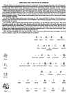
Because of its ancientness, the pictorial Chinese script has information for us from the very earliest times. In picture writing, it portrays facts recorded in the book of Genesis.
C.H. Kang and Ethel A. Nelson did intensive research into that script and wrote the book, The Discovery of Genesis: How the Truths of Genesis Were Found Hidden in the Chinese Language. This is a fascinating volume, one you will want to read for yourself. Here are a few insights from the book:
(1) The Chinese character for Devil is formed from three other characters: man, garden, and private (Genesis 3:1-7).
(2) Tempter is a combination of three words: devil, cover, and tree (Genesis 3:1-6).
(3) Righteousness combines sheep, I or me, and hand (Genesis 4:2-5). (Genesis 4:2-5). (Genesis 4:2-5).
(4) The Chinese word for Total is a uniting of eight people, who join hands over the earth (Genesis 7:7,13; 8:13-16).
(5) Boat, in Chinese, brings together two words into one. The two words are vessel and eight (Genesis 7:7,13; 8:13).
(6) Rebellion and Confusion have the same script: a linking together of the words for tongue and walking (Genesis 11:4-9).
(7) One example of the unusual discoveries is Garden or Field which is a square. Inside the square are four straight lines radiating outward in a "plus sign" shape. According to Genesis 2:9-14, a river flowed outward in four streams and watered the entire garden.
Kang and Nelson revealed dozens of other Chinese words suggesting a relationship to Genesis. You will find the entire book very interesting. (In 1997, Dr. Nelson, Dr. Ginger Tong Chock, and Richard E. Broadberry released God’s Promise to the Chinese, a book which updated the study using oracle bone characters, the most ancient Chinese writing known.)
As they arrived in their new home after the scattering from the tower of Babel, and formulated their picture writing, the Chinese placed in their "picture words" recollections of those important earlier events: the Fall of Man, the early sacrificial system, the worldwide Flood, and the Tower of Babal. These are four of the outstanding events described in Genesis 3 to 11.
You may recall our earlier mention that the Chinese recorded the solar eclipse of 2250 B.C., the earliest exact historical date in history and confirmed scientifically (see chapter 4, Age of the Earth). Biblical records indicate the Flood occurred very close to that time.
THE SIZE OF NOAH’S ARK—Based on the Hebrew cubit of 18.5 inches [563.88 cm], it has been estimated that if that great boat—the Ark—was only one-half the size stated in Genesis 6:14-16—and omitting water creatures—it could still have held two or seven of each basic kind of animal and bird. The remainder of the boat was probably used for food storageif that great boat—the Ark—was only one-half the size stated in Genesis 6:14-16—and omitting water creatures—it could still have held two or seven of each basic kind of animal and bird. The remainder of the boat was probably used for food storage. But that estimate is based on the smaller Hebrew cubit in the dimensions of the Ark. However, it is very likely that Moses used the cubit of his time—the Egyptian cubit—when giving the dimensions of the Ark. This would make that giant boat even larger. Here is the data: But that estimate is based on the smaller Hebrew cubit in the dimensions of the Ark. However, it is very likely that Moses used the cubit of his time—the Egyptian cubit—when giving the dimensions of the Ark. This would make that giant boat even larger. Here is the data:According to Genesis 6:15, the Ark was 300 cubits long, 59 cubits wide, and 30 cubits high. The Babylonian cubit was 19.8 inches [603.504 cm], the later Hebrew regular cubit was 17.5 inches [533.4 cm], and the Egyptian cubit was 20.65 inches [629.12 cm].
Based on the Hebrew cubit, the dimensions of the Ark would have been 437.5 feet [1,333 dm] long, 72.92 feet [222 dm] wide, and 43.75 feet [133 dm] high. With three decks in the Ark, it had 95,747 square feet [29.18 dkm2], and a total volume of 1,395,734 cubic feet. Its cubic tonnage would be 13,960 [1042 mt3]. Based on the Egyptian cubit used in the time of Moses, the measurements of the Ark would be 516.25 feet [1,573 dm] long, its width would be 86.04 feet [262 dm] wide, and its height would be 51.625 feet [157 dm]. On this basis—with three stories—its square footage would be 1,332,545 square feet [123,793 m2] , and its volume would be 2,293,087 cubic feet [64,894 m3] . Its cubic tonnage would be 22,930 [17110 mt]The Ark was a barge, not a ship with sloping sides, so it had a much larger carrying capacity. It has been reckoned that, even if measured by the smaller 18.5-inch [563.88 cm] cubit of later times, the Ark would have been so huge that 522 modern railroad box cars could have fitted inside it! One each of every species of air-breathing creatures in the world today could be comfortably carried in only 150 box cars.
For 4,000 years after the Ark was constructed, ships rarely exceeded 150 to 200 feet [457-6,096 dm] in length. It was not until 1854 that a ship was built with a longer length than the Ark: the Eturia, a Cunard liner constructed in England. It was not until after World War II that ships were built which had a larger volume and cubic tonnage—the ocean-going oil supertankers.
FLOOD CHRONOLOGY—In a chapter of this nature, we should provide the Biblical dating of the Genesis Flood. Although it is impossible to provide exact dates, in accordance with conservative Biblical chronology, Creation occurred at approximately 4004 B.C. (4,000 years before the birth of Christ). The Flood began 1656 years later (1656 A.M. [anno mundi - year of the world]), which would be approximately 2348 B.C. That is the closest approximation we can arrive at.Here, according to Genesis 7 and 8, is a brief chronology of events during the Flood (the following figures are based on a thirty-day month):
40 days—Rain fell for forty days (7:4, 12, 17).110 days—The waters rose and reached their greatest height at some time during or at the close of another 110 days (Geneses 7:24).
74 days—The "going and decreasing" of the waters occupied 74 days, then the tops of the mountains were seen (8:5, note the margin).
40 days—Forty more days passed and then Noah sent out the raven (8:6-7).
7 days—Seven days elapsed and then Noah sent out the dove for the first time, but the "waters were still on the face of the whole earth" (8:8; cf. 8:10, "other seven days").
7 days—Seven days later, the second dove was sent out the second time and found the olive leaf, because "the waters were abated" (8:10).
7 days—After seven more days, the dove was sent out a third time and did not return, because "the waters were abated" (8:12).
29 days—The total so far is 285 days, but comparing the dates in 7:11 with the next event in 8:14 yields a total of 314 days. During that additional 29 days, Noah waited until "the waters were dried from off the earth" to remove the covering from the Ark. By that time the raven ceased to "go to and fro" (8:7).
57 days—From the time when the covering of the Ark was removed, to the day they and the animals left the Ark, 57 more days elapsed. When the "earth" was adequately "dry" Noah left the Ark (8:14).
371 days—From the time that the rain first began falling until the Ark was vacated, would be a total of 371 days.
Some suggest that the flood waters reached their maximum height in 40 days while others think that they continued to rise for the first 150 days.
The fresh olive leaf (which was found shortly after the Ark beached in the Ararat Mountains) would have had as much as four months to sprout from an asexually propagated olive branch buried near the surface of the soil.
CREATION STORIES—Before concluding this section, it is of interest that, not only are Flood stories found worldwide, but Creation stories are also. In both we find parallels to the accounts given in Genesis. We would not have room here to discuss this; but, for example, man was created from clay, and there was an ominous serpent that caused mankind great trouble. It is frequently thought to have been winged.
"An extraordinary number of religious traditions among diverse peoples—Jews, Christians, Moslems, Native Americans, Polynesians, Austrahari aborigines—describe living things as having been originally shaped from clay."—*R. Milner, Encyclopedia of Evolution (1990), p. 84.
"Dragon legends have persisted for centuries in Norse epics, medieval English ballads, Wagnerian operas, Japanese art and Chinese folktales."—*Op. cit, p. 145.
3 - CONDITIONS BEFORE THE FLOOD
What were conditions like prior to the Flood? There are several pre-Flood evidences that we find today:
WARMER CLIMATE—Fossil-bearing rocks from all "ages" reveal that a worldwide warm climate once existed, with no distinct climatic zones such as we now have. For example, palm trees and giant ferns grew in the far north and far south. These were buried at the time of the Flood, revealing what the local climate was like prior to that time.
"It has long been felt that the average climate of the earth throughout time has been milder and more homogenous than it is today. If so, the present certainly is not a very good key to the past in terms of climate."—*R.H. Dott and *R.L. Batten, Evolution of the Earth (1971), p. 298.
Prior to the Flood, the climate worldwide was warm and uniformly pleasant.
"In those days [when the dinosaurs lived] the earth had a tropical or sub-tropical climate over much of its land surface, and in the widespread tropical lands there was an abundance of lush vegetation. The land was low and there were no high mountains forming physical or climatic barriers."—*E.H. Colbert, "Evolutionary Growth Rates in the Dinosaurs," in Scientific Monthly, August 1949, p. 71.
"Climatic conditions were then much more uniform over the earth than now. Considerable limestone formations, of Cambrian age at high latitudes, indicate strongly that they were there deposited in relatively warm or temperate waters."—*W.J. Miller, An Introduction to Historical Geology (1952), p. 116.
"The general distribution and character of the rocks and their fossil content point to more uniform climatic conditions than those of today. Fossils in the Arctic rocks are not essentially different from those of low latitudes."—*Op. cit., p. 143.
"In the case of the Devonian, such evidence is indicative of a worldwide mild climate."—*O.D. von Engeln and *K.E. Caster, Geology (1952), p. 596.
"As for the earlier Paleozoic periods, the character and distribution of Mississippian fossils rather clearly prove absence of well-defined climatic zones like those of today."—*W. J. Miller, An Introduction to Historical Geology (1952), p. 169.
Even evolutionists recognize that coal was formed from deposits of massive amounts of vegetation, primarily trees. It is now known that large coal deposits exist today in the continent of Antarctica. This is another evidence of an earlier, worldwide warm climate.
"There would have been no white polar caps or reddish-brown desert regions, for thick green vegetation covered almost all of the land areas, even in polar regions (thick coal deposits have been discovered in the mountains of Antarctica)."—John C. Whitcomb, Early Earth (1986), p. 22.
The Antarctic once had an abundance of vegetation and large trees, as is shown by "widespread discoveries of coal and petrified wood." The Arctic regions were once tropical:
"Geologists mine coal for science in . . the Horlick Mountains [of the Antarctic]. The Ohio State University scientists found coal that dates from the Permian Period, about 250 million years ago, when Antarctica had a comparatively warm climate." "Five geologists last year drilled and blasted 20 feet to bring out virtually unweathered Antarctic coal. Widespread discoveries of surface coal and petrified wood show that Antarctica had luxuriant vegetation 250 million years and more ago."—*D.M. Tyree, "New Era in the Loneliest Continent," Natíonal Geographic, February 1963, pp. 288, 296.
"Baron Toll, the Arctic explorer, found remains of a saber-toothed tiger and a 90-foot [274 dm] plum tree with green leaves and ripe fruit on its branches over 600 miles [966 km] north of the Arctic Circle in the New Siberian Islands. Today the only vegetation that grows there is a one-inch high willow."—Joseph C. Dillow, The Waters Above (1982), p. 346.
"Fossil plants found by Chilean scientists on King George Island puts Antarctica’s ancient past in a temperate clime. Further proof of the continent’s warm ancestry lies in its coal, the transformed remains of forests long dead."—*W.R. Curtsinger, "Antarctica’s Newer Side," National Geographic, November 1971, p. 653.
"Dr. Jack A. Wolfe in a [1978] U.S. Geological Survey Report told that Alaska once teemed with tropical plants. He found evidence of man-groves, palm trees, Burmese lacquer trees, and groups of trees that now produce nutmeg and Macassar oil."—*Op. cit. p. 348.
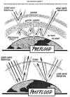
WATER VAPOR—What produced the changeover from a worldwide warm climate to our present climate zones that vary between very hot to icy cold? It was probably a change in the earth’s atmosphere.
There are three factors in the atmosphere that provide us with whatever greenhouse-type climate we have today: ozone, carbon dioxide, and water vapor. If, prior to the Flood, one or more of these were more abundant in the air above us, a profound change in our worldwide climate would occur. The most powerful of the three is water vapor. Indeed, a lot of the water in our present oceans, came out of the skies at the time of the Flood!
THE VAPOR CANOPY—The pre-Flood atmosphere contained an immense amount of moisture, which made the entire planet warm.
The Vapor Canopy
 CLICK TO
ENLARGE
CLICK TO
ENLARGE
A universal water-vapor blanket must have covered our planet in ancient times. It is called the "vapor canopy." The evidence is clearly available that tropical plants were once in the far north and south. Only a great increase in encircling water could possibly explain that earlier worldwide warm climate.
"An increase of water vapor . . would raise the temperature of the earth’s surface . . and would increase the temperature of the air at a height of four or five miles [6-8 km] more than that at the surface, and so lessen the decrease of temperature with height."—*C.E.P. Brooks, Climate Through the Ages (1949), p. 115.
Apart from a massive increase in pre-Flood water vapor, the situation we find in the rock strata is unexplainable.
"There is little evidence that climatic belts existed in the earlier history of the earth, yet climatic zonation, both latitudinal and vertical, is clearly apparent in all parts of the earth today. This anomalous situation is difficult to explain.
"It is impossible to reconstruct a super-continent which could lie entirely within one climatic regime. Any rotating planet, orbiting the sun on an inclined axis of rotation, must have climatic zonation. It is obvious, therefore, that climatic conditions in the past were significantly different from those in evidence today."—*Edgar B. Heylmun, "Should We Teach Uniformitarianism?" in Journal of Geological Education, January 1971, p. 36.
"The principle atmospheric absorber for the entrant sunlight is water vapor. Absorption by ozone being a minor factor qualitatively, the other gases are virtually transparent. Absorption of the outgoing radiation from the earth is again largely due to water vapor, with carbon dioxide and ozone playing lesser roles . . The part absorbed tends to warm the atmosphere, and just as the warm glass of the greenhouse tends to raise the temperature of the interior, the water vapor tends to raise that of the earth’s surface below it. This surface, or any object on it, is constantly exchanging radiation with the water vapor in the atmosphere, so the temperature of the surface is closely dependent upon the amount and temperature of this vapor."—*Harold K. Blum, Time’s Arrow and Evolution (1951), p. 57.
"Calculations show that a 50-percent decrease in the amount of carbon dioxide in the air will lower the average temperature of the earth 6.9 degrees Fahrenheit. We can be reasonably sure that such a sharp drop in temperature would cause glaciers to spread across the earth."—*Gilbert N. Plass, "Carbon Dioxide and Climate," in Scientific American, Vol. 201, July 1959, p. 42.
It has been suggested that our planet was not inclined 23 degrees prior to the Flood. But, if the earth was not then on an inclined axis (which may well not be true), worldwide yearly temperatures would be even more extreme than now! The only solution to the problem is that a sizable portion of the water in the oceans was once in the skies overhead.
LOWER SEA LEVELS—Before the Flood there were probably only broad rivers. The enormous concave ocean basins we have today—in some places over five miles [8 km] deep—were not needed then. The entire earth must, indeed, have been very beautiful.There are several lines of evidence that tell us that, at some earlier time, the ocean basins FILLED with water. Here are some of them:
(1) Seamounts were first discovered by a naval captain during World War II. As a personal research project while on trips back and forth across the Pacific, Harry H. Hess, commander of an attack transport, the U.S.S. Cape Johnson, kept his deep-water echo sounder turned on all the time. Continuous profiles of the sea bottom were recorded on graph paper. Analyzing the data, he discovered extinct volcanoes hundreds of feet beneath the sea with their tops flattened off.
None of them broke the surface of the ocean. The name "seamounts" was given to these formations. (An alternate name for them is "guyots.") What could have caused them?
Volcanic activity began before the Flood ended. The volcanoes in the basin of the ocean, which became extinct before the seas had filled, had their summits eroded away—flattened out—by storm and wave action as sea level reached those summits. The oceans kept filling and the horizontal tops became submerged, some distance below the surface.
This would also explain some of the coral atolls in the Pacific. Coral only grows near the surface, yet the remains of earlier coral are to be found deeper in the ocean. It has been said that low-lying and partially or totally submerged volcanoes, in the center of these coral formations, probably sunk at some time in the past. That is possible. Or they could have been covered by the rising ocean.
Oceanic volcanoes could also have blown their tops, as Krakatoa did a century ago, but such explosions would not lower the tops as far down as they presently are, nor would they flatten the tops. As the oceans neared their present level, infilling would slow and coral would have time to build atolls above those particular guyots.
(2) Similarities between plants and trees of now widely separated areas. Vegetation in Brazil has a number of remarkable similarities to that of western Africa. Climatic conditions may be the sole cause of this similarity of vegetation on separated continents. But the possibility that the South Atlantic in ancient times may not have existed as a broad ocean could also be a factor.
It is clear that remarkable evidence of a former worldwide Flood is abundant. Wherever we turn we encounter new insights into its effects. A sizable amount of additional evidence will be found in the appendix (at the back of this chapter, Effects of the Flood, on our website). The Whitcomb and Morris’ book, The Genesis Flood, will also provide you with much additional scientific data on this topic.
4 - EFFECTS OF THE FLOOD With the exception of its initial Creation, our world has been changed more by the Flood than by any other event in the history of this planet. There is hardly a place where you and I can look, which has not been drastically affected by the Flood and its immediate aftereffects: the deserts, the seas, the river canyons, the hills, the plains, and the mountain ranges. Here are several examples of these effects: CONTINENTAL SHELVES—The continental shelves that surround all the continents on the globe are another evidence of a lower—or a gradually rising-sea level at some earlier time. These are ledges protruding out from land beneath the oceans. From shoreline at the edge of the continents, the sea slowly becomes deeper for a number of miles. This outward extension can be as much as 750 miles [1206.9 km], but the average width is about 42 miles [67.59 km]. Then, at a definite, higher first point, it descends gradually to a lower second point which has a maximum depth of about 300 feet [914 dm] to about 1500 feet [1,310 dm], with a mean depth of about 430 feet [4,572 dm]. Beyond this second point, it then descends more rapidly to the sea bottom.Here are four possibilities for the origin of continental shelves:
(1) The first or second point of sudden change may mark the ancient sea level.
(2) The second point may also mark the freeze point, the place where the gradually filling sea greatly slowed for a time as the rapidly obscuring volcanic dusts in the skies caused the polar areas to begin capturing large quantities of water and transform it into thick masses of ice. During that time of slower infilling, gigantic waves and storms could have eroded out massive sections.
Above the first point where the drop is much more shallow, the storms of the main Flood may have subsided and the gentler seas may have caused less erosion as infilling was completed.
(3) The first point edge of the shelves may also mark the point of orogeny (mountain building), the point where the continental blocks began uplifting and/or the—what is now marine—blocks lowered as the result of fault slippage.
(4) The water in the oceans rose to a certain height. Then, later, at the time of glacial-melt, as the ice sheets melted, this water flowed into the seas brought the water level up to its present height.
Those are the possibilities, but however it may have happened, it took the Flood to produce the continental shelves.
"The ocean basins can thus be characterized as overfull—water not only fills the ocean basins proper [coming up to the continental shelves], but extends out over the low margins of the continents [overflowing the shelves]."—*J.V. Trumbull, et. al., "An Introduction to the Geology and Mineral Resources of the Continental Shelves of the Americas" in U.S. Geological Survey Bulletin 1067 (1958), p. 11.
"Perhaps the ocean volume increased enough to explain most of the relative sinking of the seamounts. If the latter idea is correct, something on the order of a 30 percent increase in the volume of the oceans must have occurred during the last 100 million years."—*Edwin L. Hamilton, "The Last Geographic Frontier: The Sea Floor," in Scientific Monthly, December 1957, p. 305.
Later in this chapter, in the paragraph section "Mountain Building," indication is given that the mountains and continents rose both during the latter part of the Flood (late Pliocene) and again just after it (Pleistocene). This twofold uplift might help explain the two continental shelf point pauses in rising ocean levels.
SEAMOUNT CORALS—Coral and foraminifera are small plants containing sizable amounts of calcium, which grow close to the surface of the sea. Deposits of these small creatures have been found on the flat-topped seamounts. At some earlier time coral were growing on those deeply submerged seamounts! This is an important point, since coral cannot live below a depth of 200 feet [609 dm]. At some earlier time, the sea must have been far below its present sea level.The 100 million year estimate, given by *Hamilton in the above quotation, is based on the fact that coral can only live and grow near the ocean’s surface. Evolutionary theory has assigned those deposits to the late Cretaceous or early Tertiary, but a sudden infilling of water by the Flood could answer the point just as well. It is of interest that a full 30 percent of the oceans lies above those coral deposits on the submerged seamounts!
"For some reason that is not known, probably having to do with isostatic adjustment or subcrustal forces, the whole great undersea range sank and, initially, sank fast enough to kill the reef coral when the coral dropped below its life zone of upper water."—*Op. cit., p. 303.
Evolutionists think that the cause was a lowering of the ocean basins. But that solution would only add 70 percent more water to those oceans! Something more beside seafloor sinking is needed.
Submarine canyons are yet another evidence that lower seas gradually filled and became our present large oceans. We will discuss these canyons later in this chapter.
ORIGIN OF THE OCEANS—The Flood, described in Genesis 6-9, has had more profound effects on our planet than probably any other single event since its initial creation, with the exception of the Fall of man. An astounding example of this is the vast oceans which surround the continents on every side.With our present continents and deep ocean basins, if all the water in our present atmosphere were to suddenly fall as rain, it would cover the entire surface of the globe to an average depth of only two inches (*C.S. Fox, Water, 1952). Prior to the Flood, we apparently had a far greater amount of moisture in the atmosphere. That would have given a more uniformly warm climate to the entire world, and would explain why fossils of tropical plants have been found in the far north and south. Massive amounts of water poured out of the skies. In addition, large amounts of water apparently were released from within the earth. Because of that, we now have so much water in our oceans that, if the land were leveled out, "the Earth would be completely covered by water about 0.75 mile [1.2 km] deep" (Creation Research Society Quarterly, June 1987, p. 27). Another estimate figures it at 1.7 miles [2.7 km]: CRSQ, September 1987, p. 54.
There are evidences that much of the present sea bottom was once dry land:
"There are fossil landforms preserved in the depths of the sea, where they are disturbed only by light currents and the slow rain of pelagic material from the waters above."—*E.L. Hamilton, "The Last Geographic Frontier: The Sea Floor," in Scientific Monthly, December 1957, p. 303.
Immense upheavals as well as sinkings of land must have taken place in order to provide a place to hold the oceans. If that had not occurred, the entire earth today would be under water and there would be no continents. Very frankly, this was an act of Divine providence. The ocean basins had to sink, and the continents rise—or there would be no dry land after the Flood.
By the end of the Flood year, recorded in Genesis 7 and 8, "the valleys [basins] sank down" and the great masses of water which "were standing above the mountains" "fled" and "hurried away. . to the place which Thou didst establish for them. Thou hast set a bound [the shorelines] that they may not pass over; that they return not to cover the earth." Psalm 104:6-9.
SUBMARINE CANYONS—Another relic of the Flood is the great canyons cut into the ocean floor. These are to be found just below where each of our major rivers dumps into the ocean. Known as "submarine canyons," those canyons could only have been made if the floor of the ocean basins sank, the ocean level was then lower, and was gradually filled by rain from the skies and by water pouring down into it from these waterways. One example is the canyon in the ocean just opposite the Hudson River in New York.The evolutionary position, that the oceans did not fill, leaves them no solution to the origin of submarine canyons.
"The difficulties encountered in explaining the lowering of sea level necessary for the canyons to have been cut by streams [with a volume of water such as we have today] seem insurmountable . . If Tolstoy’s conclusion that Hudson Canyon extends down to a depth of 15,000 feet [4,572 m] [!] is correct, the magnitude of lowering of sea level to permit subaerial canyon cutting seems beyond any possibility of realization."—*William D. Thornbury, Principles of Geomorphology (1954), p. 472.
You will find these diagonal canyons, cut into the continental shelves, out beyond the mouths of all the great rivers of the continents: the Colorado, Columbia, Amazon, etc.
Such colossal river currents could not run downward, if the oceans were earlier at their present height. Scientistists cannot account for those canyons. Some suggest "turbidity currents," as the answer while others recognize that something far greater was involved. .
"Can we, as seekers after truth, shut our eyes any longer to the obvious fact that large areas of sea floor have sunk vertical distances measured in miles."—*Kenneth K. Landes, "Illogical Geology," in Geotimes, March 1959, p. 19.
Brown discusses their immense size and significance.
"On the ocean floor are several hundred canyons. Some of these submarine canyons rival the Grand Canyon in both length and depth. One canyon is three times deeper than the Grand Canyon. Another is 10 times longer, so long that it would stretch across the United States. Many of these V-shaped canyons are extensions of major rivers. Examples include the Amazon Canyon, the Hudson Canyon, the Ganges Canyon, the Congo Canyon, and the Indus Canyon.
"How did they get there? What forces could gouge out canyons that are sometimes 15,000 feet below sea level? Was the ocean floor raised or the ocean surface lowered by this amount so ancient rivers could cut these canyons? If so, how? Canyons on the continents were supposedly formed by the cutting of fast flowing rivers and surface drainage. However, the [current] flows measured in submarine canyons are much too slow—generally less than one mile per hour. Frequently the flow is in the wrong direction. Submarine landslides or currents of dense, muddy water sometimes occur. However, they would not form the long, branching (or dendritic) patterns that are common to river systems and submarine canyons. Besides, experiments with mud-laden water in actual submarine canyons have not demonstrated any canyon-cutting ability."—Walter T. Brown, In the Beginning (1989), p. 63.
HIGHER LAKES—It is quite clear that at some earlier time there was much more water in the enclosed lake basins of the continents.Anyone who has ever driven into the Salt Lake City area cannot help but notice the high-water marks on the surrounding mountains. Four distinct marks are to be seen, the highest of which is about 1,000 feet [3,048 dm] above the present level of Great Salt Lake. At some earlier time an area of 20,000 square miles [51,798 km2] was covered by this ancient lake (scientists call it "Lake Bonneville").
Another basin of an ancient lake ("Lake Lahontan") is to be found in Nevada; it once filled 8,400 square miles [21,755 km2]. *Flint, in Glacial and Pleistocene Geology, lists 119 ancient lakes which are now dry or nearly so.
Such raised beaches and terraces formed by ancient lakes are to be found all over the world...
"There are many examples outside the United States of similar lake expansions during pluvial glacial times. Lake Texcoco in Mexico was at least 175 feet [533 dm] higher than it is now; Lake Titicaca in South America was 300 feet [914 dm] higher; the Dead Sea was 1400 feet [4,267 dm] higher, and as many as 15 abandoned strand lines have been observed around it; the Caspian Sea was at least 250 feet [762 dm] higher and was apparently confluent with the Aral Sea to the east and the Black Sea to the West."— *W.D. Thornbury, Principles of Geomorphology (1954), p. 418.
LARGER RIVERS—There was also a far greater volume of water flowing at some earlier time in the rivers. It is common today to see small streams flowing between the steep, high sides of large canyonsThere was also a far greater volume of water flowing at some earlier time in the rivers. It is common today to see small streams flowing between the steep, high sides of large canyons. Obviously, at some earlier time gigantic waterways must have flowed there for a time. In addition, extensive deposits of sediments (alluvium) left by these ancient rivers are to be found at higher levels.
We consistently find valleys with small streams in their center, with evidences that once a very large river coursed down the center of the valley.
"If a stream, or more correctly the size of the stream meanders [the serpentining of the stream back and forth within its base floodplain], is too small for the size of the valley, the stream is said to underfit; if too large, it is referred to as overfit. It is difficult to cite examples of overfit rivers, or streams with floodplain too small for the size of the stream. Hence there may well be a question whether overfit streams exist . . The underfit condition can persist indefinitely; hence many examples of such streams exist."—*W.D. Thornbury, Principles of Geomorphology (1953), p. 156.
"Valleys commonly appear to be far too large to have been formed by the streams that utilize them."—*O.D. von Engeln and *K.E. Caster, Geology, pp. 256-257.
Then there are the massive flood plains, remnants of earlier gigantic river overflows. There is an enormous flat area on both sides of the Mississippi River. This is its flood plain, and it extends for many miles. In ancient times, this was part of a gigantic river, now referred to as the "Teays River.". There is an enormous flat area on both sides of the Mississippi River.
IMMENSE EROSION AND SEDIMENTATION—(*#1/6 Water Power*) Tremendous quantities of water flowed outward from the land, and it took a lot of soil and sediment with it. In many parts of the world, only sand remains. Tremendous quantities of water flowed outward from the land, and it took a lot of soil and sediment with it. In many parts of the world, only sand remains. This would be but another result of the Flood. We see evidences of it today as we look at our mountains, plains, deserts, and waterways. Consider the Grand Canyon of Arizona.One important result of all this was the burial of so much vegetation and animal life. There are places in our world where fossil-bearing sedimentary rock is several miles deep. From bottom to top, the sedimentary rock provides fossil evidence of a gigantic yet rapid catastrophe. Prior to the Flood this sedimentary strata did not exist.
WAVE EROSION—Water is powerful, not only when it is running, but when it strikes a surface head on. Ocean waves can be very destructive, as we are told by Rachel Carson in The Sea Around Us. *King also mentions this:"Waves are seldom more than twenty-five feet high; but violent storms may raise them to sixty feet, and there are unverified reports of even greater heights . . The immense striking power of a wave cannot be realized until it hits an object that cannot float with it. Waves striking the shores of Tierra del Fuego can be heard for twenty miles [32 km]. Spray from a storm wave has been hurled to the top of a lighthouse nearly 200 feet [609 cm] above sea level. The force of waves striking the shore can be measured, and has been found to reach three tons per square foot [2.7 mt per .09 m2]."—*Thomson King, Water (1953), p. 49.
Terrible storms raged during the Flood. Immense quantities of water were flowing, grinding, wearing away surfaces. Massive wave action took its toll also. All this resulted in an astounding rate of erosion, which produced sediments which resulted in the thousands of feet of sedimentary rock strata which we see today.
ROCK STRATA—Several evidences in the sedimentary rock strata indicate that the sedimentary rock strata were all laid down rapidly at one time, thus indicating a single worldwide Flood occurredSeveral evidences in the sedimentary rock strata indicate that the sedimentary rock strata were all laid down rapidly at one time, thus indicating a single worldwide Flood occurred.(1)
Sedimentary rocks, sometimes deep ones even down to the Cambrian, are in an unconsolidated state. That is, they have not been pressed together into solid rocks. Yet if these stones had been lying under millions of tons of overrock for millions of years, they would long ago have consolidated.(2) The fossils and the rock strata indicate rapid deposition, due to a sudden worldwide Flood, rather than being slowly laid over a period of long ages. We discussed this in detail earlier in this chapter in the section, Fossils and Rock Strata. There are thousands of cubic miles of such materials, yet hardly any of it is being made today. The entire process took place rather quickly at some past time.
(3) The strata are confused and often crushed. If slow, uniform layering occurred as a result of erosional forces, the layers would also be uniform and fairly flat. As it is, what we see is the result of a terrific upheaval.
(4) Geologists well-know that rivers only cut through hard materials when they rush fairly straight down steeply slanted surfaces. In contrast, rivers that meander serpentinely are slow-moving waters going through more level land and can then only cut through softer materials. But what we find is evidence that, at some past time, meandering cut through, what is today, thick rock—at such locations as the Colorado River, in the Grand Canyon of Arizona, and the San Juan River in Colorado.
Such river canyons were not cut by rivers "over millions of years," but instead were quickly cut through while they were still soft and their strata had only recently been laid.
VARVE DATING—"Varved clays" are banded sediments, with each band quite thin with light and dark color gradations between them. "Varve chronology" is another evolutionary means of dating the sediments, for evolutionists theoretically interpret each varve as an annual (one year) deposit. But we find pebbles, plants, insects, and dead animals in the varves. How does one explain a dead fish lying on the bed of a lake for about two hundred years without rotting while the slowly accumulating sediments gradually cover it and then fossilize it? Where does this occur in modern lakes? There is a lot more that could be said on this topic, but the above should be sufficient to disprove the theory of "varve dating." FACTS ABOUT THE DINOSAURS—Very high up in the theoretical column of rock strata we find the Mesozoic, which includes the Triassic, Jurassic, and Cretaceous. In these levels we find the dinosaurs. Apparently reptilian in nature, many of these were gigantic creatures. The dinosaurs died as a result of the Flood."One of the important contemporary scientific debates is about the causes of the mass extinctions at the close of the Cretaceous epoch, about 65 million years ago . . Scientists refer to this crucial, enigmatic transition in the history of life as the K/T boundary. The Cretaceous epoch is abbreviated as K to distinguish it from the earlier Carboniferous (coal-forming) epoch, abbreviated as C. Sedimentary rock layers above the Cretaceous, which include the fossil record of the Age of Mammals, are traditionally called Tertiary or T."—*R. Milner, Encyclopedia of Evolution (1990), p. 246.
It has been suggested that the dinosaurs were killed by volcanoes, climatic changes, or the eating of their eggs by other animals. Yet far more delicate wildlife have survived volcanoes, climatic changes, and egg predators. Evolution has no answer to the extinction of the dinosaurs.
"These are some of the theories that have been advanced to explain the sudden extinction of dinosaurs throughout the world. Each theory will explain the death of some dinosaurs in some places, but attempts to apply any of them, or combinations of them, to worldwide extinction have failed. This dinosaur story is like a mystery thriller with the last pages torn out. That is true and the paleontologist knows it. He also knows the riddle will probably never be solved."—*J.M. Good, *T.E. White, and *G.F. Stucker, "The Dinosaur Quarry," U.S. Government Printing Office (1958), p. 26.
You have just completed
Chapter 14 Effects of
the Flood part 2
NEXT—
Go to the next file in this
series,
Chapter 14 Effects of the Flood part 3
EVOLUTION FACTS, INC.
- BOX 300 - ALTAMONT, TN. 37301